In June of 1283 Dafydd ap Gruffydd was captured by the invading army of Edward I. Thanks to a betrayal by Einion. Bishop of Bangor, he and his family had been discovered at a place called Nanhysglain, allegedly somewhere close to the rocky mountain of Bera Mawr, in the Carneddau region of Snowdonia.
This scant patch of detail is pretty much all that the internet can tell us about the capture of Dafydd, the last true Prince of Wales. One or two places mention that Dafydd was injured in the capture or that the area he was hiding in was boggy, but little else. For myself, what irritates the most is that there is no mention of where precisely Nanhysglain was, or even what it was. There are almost no details about Nanhysglain whatsoever.
Medieval Welsh History is notoriously difficult to pin down. Sources, both primary and secondary, are scant when compared to other areas and regions. Most of the primary sources that do exist are either only available in Medieval Welsh or Latin, meaning that for most people, even historians, they are impenetrable. Translations into English are hard to come by, though for the more major sources like the Brut-Y-Tywysogion (Chronicle of The Princes) and Gerald’s Journey and Description of Wales they are available. Getting hold of most of the primary sources online is next to impossible. It is no wonder, therefore, that the majority of mentions of Nanhysglain are the same copy-and-pasted bits of text. Anything more is impossible to get hold of.
I suspect, however, given this is all the information the internet has, that this is in fact all the information there is, total. This is all that the sources tell us about Nanhysglain. Medieval sources such as the Brut (which I suspect is where this information comes from in the first place, but can’t confirm because the only version available in English, online, stops at 1282) were not full, detailed, accounts. They weren’t like a modern newspaper report or a full blow-by-blow synopsis going into the finest minutiae, like you would expect today. They were brief and succinct, often only mentioning in the barest of terms what happened and where and to who. Nanhysglain probably wasn’t important enough to warrant more than a passing mention.
It begs the question: Is it at all possible, with only the barest of information, to find Nanhysglain at all?
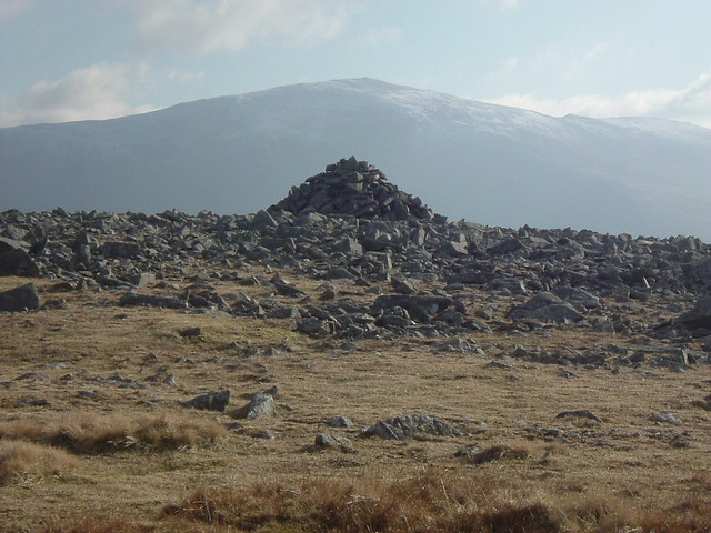
The answer is a surprising yes. If we look at the area already given to us we can narrow down the possibilities to an enormous degree. Bera Mawr is a small mountain at the pinnacle of a high plateau and to hide in such a place, without shelter, would have been impossible. The weather up there can be treacherous and can turn in an instant, even on the nicest days. Even in June. This indicates that Nanhysglain was a structure of some kind, perhaps farm or a farmstead or small holding of some description. This being anywhere to the south of Bera Mawr, which is largely flat and boggy, can immediately be discounted. It is too high and too exposed for structures of any kind, at least during the period we are looking at. The most likely areas for the building are around the streams of Afon Rhaeadr bach and Afon Goch to the north east and north west of the mountain There is also a significant depression directly to the east of the mountain which may have provided added protection from harsh weather, so this is also a possibility.
Upland farms, or ‘hafod,’ were not uncommon in Medieval Wales and were used on a seasonal basis, in the spring and summer months. Any potential farmstead in the area of Bera Mawr would almost certainly have been one of these. It could be that Nanhysglain was an abandoned or disused farmstead which Dafydd and his family took advantage of. Given the recent strife and invasion, it is not beyond the realms of possibility to suggest that the occupying family had been killed during the wars. Then again it could also have been the home of a patriotic farmer who harboured Dafydd and his family at the risk of his own life. The truth is that we do not know, but I personally suspect the latter.
The Royal Commission ‘Coflein’ website reports two medieval structures within the vicinity of Bera Mawr. One is on the banks of the Afon Rhaeadr Bach and the other on the Afon Goch. Both are described as ‘Long Huts’ and both were later redeveloped as sheepfolds. The long hut close to the Rhaeadr Bach is the more interesting for the Coflein report indicates evidence of associated settlement nearby. The chances of one of these long huts being Nanhysglain is high for both are in the right area and both, potentially, are of the correct period. Remote buildings such as these would have been a near perfect hiding place for Dafydd and his family. Which of these two buildings it was, if either, we are unable to conclusively confirm.
The name of Afon Goch also gives us another, if entirely spurious and subjective, clue. In English it means ‘Red River.’ Why it is named as such I cannot discover, but it is easy to imagine that it was named because, perhaps, it once flowed red with blood. We know that Dafydd was injured during his capture so there must have been a fight or struggle of some kind. Dafydd, being Prince of Wales, would more than likely have had a small retinue of loyal followers about him, as well as his family, and in such a case there would have been a minor skirmish, a last stand before the capture, which may have included the deaths of many in Dafydd’s retinue. They did not, we know, go quietly, and their deaths at this spot would explain the name of Afon Goch, Red River.
Another explanation for the name could be that, after the capture, the English soldiers rounded up any nearby farmers and accused them of treason for harbouring Dafydd. Perhaps, as retaliation, they massacred them in order to serve as an example to other potential traitors. Red River could have been named for that massacre. We know that this was not an entirely unpopulated landscape, unlike today. As well as the two medieval long huts there are a number of small structures and ‘settlements’ (of unknown date, and any of which could even be Nanhysglain) in the run up to Aber Falls. The population in this area would not have been sizeable but they would have been enough to form a small community of sorts, one which could have opposed the English soldiers when they came to capture Dafydd, or even have served as an example to others.
We can never know for certain the exact location of Nanhysglain, but we can imagine several possibilities from the scant evidence that is available to us. As at Climeri, where Llewelyn ap Gruffydd was killed, Nanhysglain is an important place in Welsh history. This was where the conquest truly came to an end, where the dream of a free and independent Wales was crushed for centuries to come. Going up there today, to the desolate Carneddau wilderness, you would hardly think it. There is nothing to tell you what happened here, no plaque, no carved stone. There is only silence. Perhaps the event is memorialised in the name of the Afon Goch, or perhaps not. Climb to the top of Bera Mawr, however, and look to the south. You’ll see another mountain, slightly pointy, not too far away. Here, forever, the last true Prince of Wales is remembered in the name of Carnedd Dafydd, a stone’s throw from the place he made his last stand- Nanhysglain.

Interesting ,thanks
very interesting, the secrets and history that the Carneddau hold is amazing.
Very interesting. How far from the waterfall are the long huts?
Not all that far. The one beside the Afon Goch is probably a ten to fifteen minute walk from the top of Aber Falls. I haven’t tried reaching the other hut from Aber Falls so I couldn’t tell you there.
WHY NOT WRITE A COMPREHENSIVE ARTICLE ON NANGLYSAIN THEMES FOR MAGAZINE AS
BBC HISTORY TODAY. MUCH NEEDED IS A WIDER KNOWLEDGE OF THIS. Gethin.
I’d love to, and I agree that this needs to be better known, but there’s a couple of problems. Firstly, magazines like BBC history don’t usually accept unsolicited submissions so it’s unlikely to get published. Secondly, I’m actually a modern historian and my knowledge of medieval history is quite limited. Thirdly, I have my hands full with my PhD thesis at the moment, and that’s going to keep me busy for the next eighteen months.
James.
I’ve been ispired to make a YouTube video about this after reading your brilliant blog post. Will probably be in the Spring now. The name of my channel is L T Jones
Nanhysglain is mentioned in the Record of Carnarvon (1352) as a mountain pasture, along with Nant Mawan (Anafon) and Cras. The ‘Extenta Walliae’ or Record of Carnarvon is described as a collection of extents in the counties of Carnarvon and Anglesey, taken principally in the 26th year of Edward III. Another collection of extents was ordered by Edward I following the death of Llywelyn, to note all of the lands owned by him, but that document hasn’t survived.